
Geosoft Geostring File Format (*.geosoft_string)
Geosoft geostrings (*.geosoft_string) are 3D vector files that store digitized interpretations that have been drawn on section or plan maps.
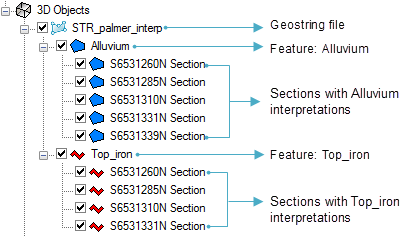
A single Geostring file can contain several different "features". Each feature typically contains several different interpretations that were digitized on section or plan maps. Features in a geostring file may be either polygon, or polyline objects. Polygon features are used to represent geological units, while polyline features can represent contacts or planar objects such as faults. Both polygon and polyline features can be stored in the same file. The feature names in a geostring file must be unique.
Geostring files store the following contents:
-
polyline features - each feature needs a unique name
-
polygon features - each feature needs a unique name
-
coordinate system - only one for the entire geostring file
-
feature attributes - information associated to the features, including feature names and colours
-
wireframing history and tie lines - during the wireframing process, the sequence of connections is stored into the geostring file as the "wireframing history"
Organization of a Geostring File
Any edits made to the interpretations on your section maps will be automatically updated in the 3D Viewer.
Got a question? Visit the Seequent forums or Seequent support
© 2023 Seequent, The Bentley Subsurface Company
Privacy | Terms of Use